Casper, WY Metropolitan Statistical Area
Appearance
(Redirected from Casper, WY MSA)
Casper, WY
Casper, WY Metropolitan Statistical Area | |
|---|---|
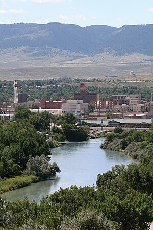
 Overview of downtown, looking south toward Casper Mountain, with North Platte River | |
 | |
| Country | |
| State | |
| Principal city | Casper |
| Time zone | UTC−7 (MST) |
| • Summer (DST) | UTC−6 (MDT) |
The Casper, WY Metropolitan Statistical Area is a United States Census Bureau defined Metropolitan Statistical Area (MSA) with the principal city being Casper in central State of Wyoming. The Casper Metropolitan Statistical Area is defined as Natrona County, Wyoming. The Casper Metro Area is the economic hub of central Wyoming. The Census Bureau 2020 report indicated that the population was 79,955.[1]
Jurisdictions
[edit]Places in the Casper Metropolitan Statistical Area [2]
| Rank | Place | 2007 Population | Notes |
|---|---|---|---|
| 1 | City of Casper | 53,003 | |
| 2 | Town of Mills | 3,479 | |
| 3 | Town of Evansville | 2,827 | |
| 4 | Vista West | 1,008 | CDP |
| 5 | Town of Bar Nunn | 2,248 | |
| 6 | Hartrandt | 686 | CDP |
| 7 | Red Butte | 432 | |
| 8 | Town of Midwest | 411 | |
| 9 | Casper Mountain | 301 | CDP |
| 10 | Homa Hills | 214 | |
| 11 | Brookhurst | 195 | |
| 12 | Meadow Acres | 179 | |
| 13 | Bessemer Bend | 170 | |
| 14 | Mountain View | 105 | |
| 15 | Hiland | 99 | unincorporated |
| 16 | Antelope Hills | 87 | CDP |
| 17 | Natrona | 61 | unincorporated |
| 18 | Powder River | 53 | CDP |
| 19 | Antelope Hills | 87 | |
| 20 | Alcova | 24 | |
| 21 | Arminto | 11 | unincorporated |
See also: U.S. Metropolitan Statistical Areas, Casper, Wyoming, Natrona County, Wyoming, the Metropolitan Areas of Wyoming, and the Laramie Mountain Range.
See also
[edit]- Natrona County, Wyoming
- Wyoming statistical areas
- List of United States combined statistical areas
- List of United States metropolitan statistical areas
- List of United States micropolitan statistical areas
- List of United States primary statistical areas
- Core-based statistical areas adjacent to Casper Metropolitan Statistical Area:
References
[edit]- ^ 2020 Census, US Census Bureau, Natrona County, Wyoming Profile
- ^ "Archived copy". www.census.gov. Archived from the original on 26 September 2008. Retrieved 13 January 2022.
{{cite web}}: CS1 maint: archived copy as title (link)
42°50′N 106°20′W / 42.833°N 106.333°W
